The Grand Canyon in 3 Chapters
A few years ago I overheard someone say that they thought the Grand Canyon was formed by a cataclysmic event. I knew this was a Young Earth view, but it didn't catch my attention and stay in my mind because it was wrong (although it is wrong). It stayed with me because I knew that the formation of the canyon itself was such a small part of a longer story and that, in the grand scheme of things, it really didn't matter how long it took . I wanted to sit down right there and write that story; a book in three chapters preceded by the third chapter of the previous book, and followed by the first chapter of the next book being currently written in the Gulf of California. If all that seems unlikely, bear with me.
Being a champion procrastinator obstructed any attempt I might have made to overcome the long series of distractions that followed shortly after my plan to write the article, so I never got around to putting digits to a keyboard until now.
But before launching into the the first chapter of the story, lets set the context.
The Colorado River is the 46th longest in the world at 2,330 km and starts almost from the centre of the country. Its source is about 3 kilometres above sea level at the La Poudre Pass in the Rockies and discharges eventually into the Gulf of California. There are quite a few dams allowing vast amounts of water to be extracted for the use of homo sapiens and the latter part of its journey is through a very arid landscape, so the waters of the colorado often, as now, don't actually reach the gulf. As well as the Grand Canyon there are lakes and swamps along its length, and it has 16 main tributaries.
The three chapters I referred to are actually the answers to three questions:
How was the rock of the Grand Canyon formed and how long did it take?
How did the rock, once formed, rise from below sea level to 2.5 kilometres above sea level, and how long did that take?
How long did it take for the Colorado river to cut through the nearly 2 kilometre depth of the Grand Canyon?

From bobbordash.com
Chapter One: How was the canyon's rock formed?
Most of the canyon's rock is sedimentary, mainly formed in layers of discharge material from rivers, but also marine precipitation both chemical and biological. These sedimentary rocks sit on much more ancient rocks.
The chart (below left) shows a section through the rock layers of the canyon and I will use its numbering of the layers throughout.

From Wikimedia Commons and www.nature.nps.gov
The bedrocks are Vishnu Schist (16), which is a metamorphic rock formed around 1.7 billion years ago. About 200 million years later magma permeated the cracks in the schist to form veins of pink Zoroaster Granite (17) which you can see in the photo (left).
Next comes ancient sedimentary rocks called the supergroup rocks (12 to 15). Formed between 1250 and 740 million years ago, they have tilted and weathered almost level.
The sedimentary layers that sit on top of the ancient rocks have a fascinating history for two reasons:
Continental drift has taken the canyon's location across a wide range of latitude over hundreds of millions of years, with climates ranging from desert to temperate and polar. Desert periods produced vast quantities of sand, later compacted to sandstone.
The cycles of warming and cooling raised and lowered sea levels, so sometimes the area was under water for long periods. It was during these phases that sedimentary deposits built most of the layers, compacting desert sand to sandstone along the way.
The next layer is Tapeats Sandstone (11), laid down in shallow tropical sea around 545 million years ago. Layer 10 is the Bright Angel Shale. It is 530 million year old and contains fossils of 47 species of trilobites and primitive molluscs. The Mauv Limestone (9) layer, dated around 515 million years is made mainly of calcium carbonate. These three layers form the Tonto Group, all of which were deposited in the warm seas.
Layers 8 to 4 were all laid down in shallow seas over a period of about 100 million years. If you are interested in more detail about these layers there is an excellent 5 page summary from University of California, Davis: http://tinyurl.com/ycvpp2xc
Layer 3 is former ancient desert. The landscape when the Coconino Sandstone (3) was being formed about 275 million years ago was an eolian desert of rolling dunes. Fossil tracks have been found of both vertebrate and invertebrate species. After this the sea level rose once again and two more sedimentary layers were deposited over about 5 million years, compressing the sand to sandstone. These are Toroweap (2) and Kaibab (1) Formations.
So the answer to the question "how long did it take to form the grand Canyon's rocks?" is somewhere between 450 and 500 million years, not counting the older rocks forming the canyons foundation. The final layer was deposited 270 million years ago, so what has been happening since then? The answer to that question takes us to chapter two.
Chapter Two: How was the canyon's rock raised to 2.5 kilometres?
The detailed story of the forces that raised the Colorado plateau is complex, but it can be summarised quite easily. The whole of the west coast of the Americas is subject to the relentless eastward pressure of the pacific sea floor. This pressure produces coastal mountains from Alaska to the tip of South America accompanied by earthquakes and volcanoes that justly earn the pacific rim the title 'Ring of Fire'. Beyond these mountains the land rises. This is especially true if there is also a mountain range east of the area, and in this case we have the Rockies, also being formed at the same time. So the Colorado plateau was squeezed between the Rockies and west coast mountains like the Coastal Range, the Sierra Nevadas and their forerunners.
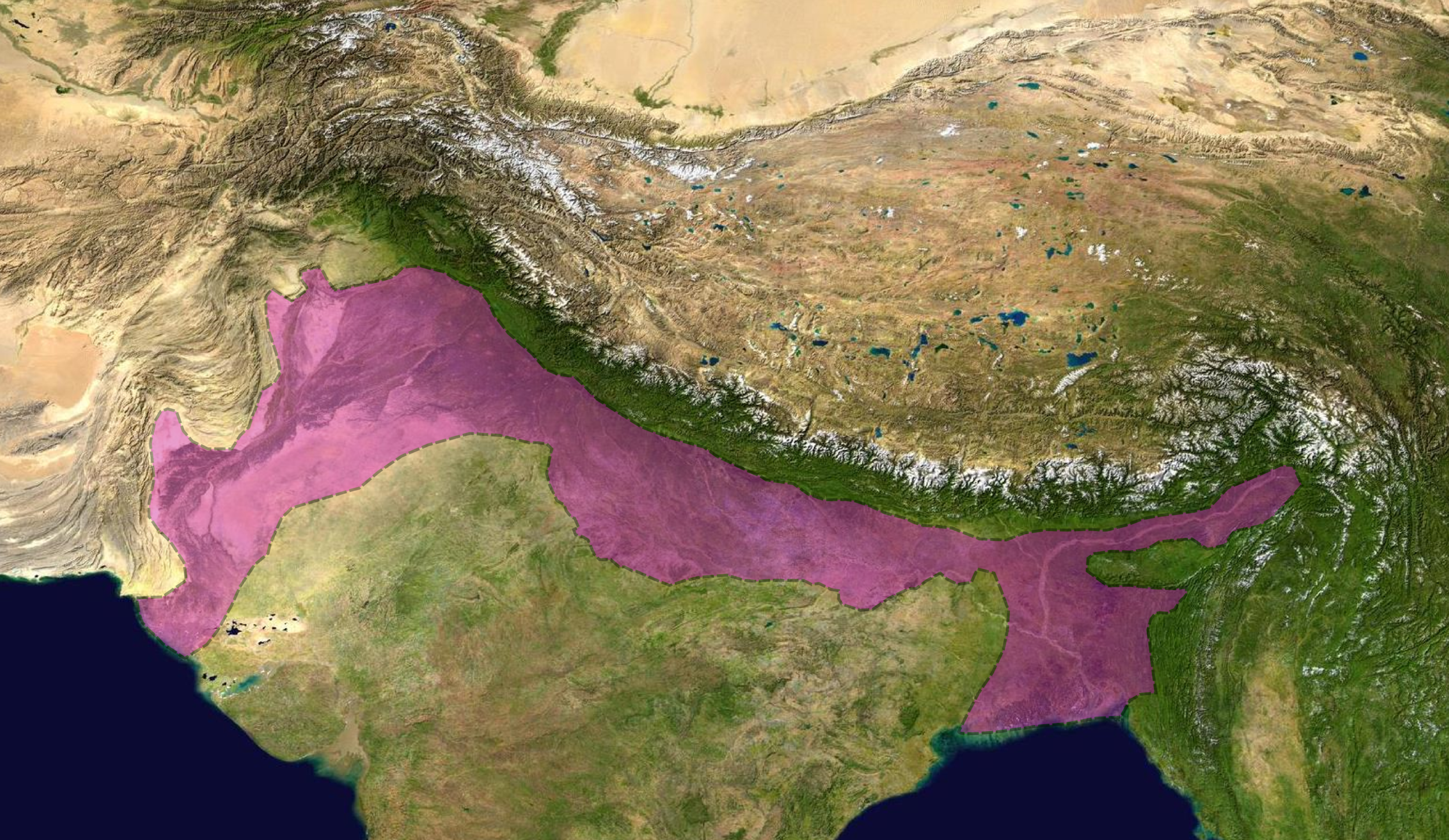
From Wikipedia: Himalayan foreland basin. The pink area is a basin formed as the indian subcontinent subducts under the mountains, creating a low lying area.
We can see this process in the more spectacular example of the Indian sub continent 'crashing' into the underbelly of Asia. After splitting from the west coast of Africa it travelled north east gathering up the intervening ocean, which gave rise to the counterintuitive Himalayan sea salt.
The Tibetan Plateau north of the Himalayas has been raised in the same way as the Colorado plateau, but much higher. The area is also called the roof of the world and averages nearly 5 kilometres above sea level. This is about two thirds of the height of the mountains themselves.
So how long did all this take? You may remember we left the sedimentary layer at sea level about 270 million years ago. From this time the area was regularly covered by shallow sea then exposed again. The plateau started to rise between about from about 80 million years ago, but didn't reach its full elevation until about 5 million years ago. So the process took roughly 75 million years.
We now come to the final chapter of our book. How long did it take for the Colorado river to cut its way through the rock layers, deliver its broken down material into the Gulf of California and give us the river we see today?
Chapter Three: What is the history of the Colorado river?
The Colorado river, starting high in the Rockies, started flowing before the plateau had risen to its highest. Changes in the topography over about 6 million years resulted in many course changes.
To the north of the Grand Canyon is the Uinkaret volcanic field. Between about 725,000 and 100,000 years ago volcanoes generated lava flows that blocked the river in the canyon multiple times. More than 13 of these blockages occurred during this period, in some cases backing the river up nearly 500 miles. These dams were not long lived and caused devastating floods. The mapping of sediment deposits downstream indicate that some of the wave crests must have been 700 metres high in the canyon. It is possible that these blockages and floods are the origin of the young Earth view of a cataclysmic event. However the sedimentary record downstream is clear about the timescales involved.
At different times the river deposited vast amounts of sediment forming deltas that prevented the river from reaching the sea, and in the present day with so much water being taken out for consumption and agriculture, the river often dries up before getting to the Gulf.
So the answer to the question "how long did the Colorado river take to carve out the Grand Canyon?' is about 6 million years.
Roundup
So we have about a billion years for the ancient rocks at the bottom of the Grand Canyon to form, followed by about 500 million years of sedimentary rocks being laid down, The remaining 270 million years to the present day was relatively quiet until about 80 million years ago when the Colorado Plateau rose from beneath the sea. The last 6 million years has seen the Colorado cut its way through the land and deposit huge amounts of sediment in the Gulf of California and the river's delta area. An excellent video (left) covering the subject is from an equally excellent website called curiosity.com.
Before and After
The sediment that built up in the ancient inland seas of North America was the first chapter of our book. Most of the sediment came from ancient rivers that now no longer exist. We can't describe them or give them names, but we know that they must have been there. This is the third chapter of the previous book and will probably remain unwritten.
This is not true of the first chapter of the next book. Cores have already been drilled in the sea bed of the Gulf of California revealing information about timescales, the fossil record and ancient climates all hidden in the Colorado river's sedimentary history. We don't know what the future of these sediments will be, they may just stay where they are, but it is more likely that they will form part of some future and unpredictable landscape.
Places like the Grand Canyon tend to be a focus for science denial because they are special and often spectacular. It is worth remembering that this history is repeated with wide variations but similar timescales for every river on the planet. Dip a glass jar into any river anywhere in the world and you will find, holding it up to the light, that it has bits in it. The bits will vary, but there will always be bits.
.